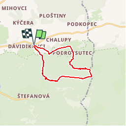
Trail Walking District of Žilina - Gorges de Janosikove Diery - Maly Rozsutec - Photo

Gorges de Janosikove Diery - Maly Rozsutec

 sit68000
sit68000

User

© OpenStreetMap contributors
Length
Length
9.8 km
Max alt
Max alt
1312 m
Uphill gradient
Uphill gradient
760 m
Km-Effort
Km-Effort  
19.9 km
Min alt
Min alt
567 m
Downhill gradient
Downhill gradient
762 m
Boucle
Boucle
Yes
Creation date :
2019-01-15 13:47:18.552
Updated on :
2019-01-15 13:47:18.552

(0 Reviews)

Walking
Walking
4h55
Difficulty : Medium

Scan this QR Code to open this trail in the SityTrail application

FREE GPS app for hiking

Logo SityTrail SityTrail

IGN / Geographical institutes

Download SityTrail from the App Store Download SityTrail from Google Play

Logo SityTrail SityTrail World

The world is yours!

Download SityTrail from the App Store Download SityTrail from Google Play Download SityTrail on Huawei AppGallery

About

Trail Walking of 9.8 km to be discovered at Region of Žilina, Unknown, District of Žilina. This trail is proposed by sit68000.

Description

Slovaquie dans les Mala Fatra

Elevation profile

Positioning

Country:
Slovakia
Region :
Region of Žilina
Department/Province :
Unknown
Municipality :
District of Žilina
Location:
Terchová
Start:(UTM)
359343 ; 5457850 (34U) N.

Trails nearby

Trail On foot Soblówka - Szlak Pasterski - Photo
On foot
PRO

On foot

Easy
Soblówka, Silesian Voivodeship, Żywiec County, Poland
4.2 km | 7.4 km-effort
1h 40min
No


Close
My subscriptions